The earliest mariners charted their courses in the open sea by examining the location of the sun and stars, the direction of currents, and even by following the movements of seabirds.
Over time, our ability to find our way around the ocean has developed to the point that today we can track the position of ships with satellites, identify hazards with camera technology and quickly share location data with other ships and the land.
Today, navigation is taking more steps forward. Maritime technology companies, including Alphatron Marine, Raymarine and ABB are working on technologies that further change the way mariners navigate.
From the merging of paper charts and digital technology to the improvement of nighttime imagery and advances in autonomous navigation, maritime technology companies are improving how we find our way around.
Furuno
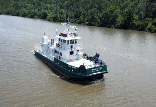
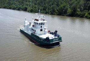
Furuno, a Japanese electronics company which focuses on radar systems, fish finders and navigational instruments, recently outfitted the National Parks Service vessel Annie Moore.
“Furuno is honored to have been selected as the provider of marine electronics aboard the Annie Moore,” said Matt Wood a national sales manager with the company’s U.S. headquarters in Camas, Washington. “She’s a remarkable vessel with an admirable mission, and we could not be more proud than to have our equipment assisting the NPS and the Army Corps of Engineers in their duties at such an important location in our nation’s history.”
The National Parks Service outfitted the vessel with a Furuno marine electronics suite that includes two NavNet TZtouch2 TZT2BB’s at the heart of her navigation system. The multi-function displays are connected to 19-inch and 24-inch multi-touch displays, driving dual DRS6AX X-Class radars. The vessel has also been outfitted with the NavPilot 711C autopilot, which provides precise heading information through the SC70 satellite compass.
The SC70 also provides a variety of additional data, including GPS positioning, ROT (Rate Of Turn), COG (Course Over Ground), SOG (Speed Over Ground), and three-axis speed data (bow, stern, and longitudinal) to assist with critical maneuvers such as safe docking and berthing.
These low-noise, lightweight radars provide leading-edge short-range target detection and feature fast target tracking, instantly displaying any target’s course and speed vectors for the ultimate in situational awareness and safety for passengers and crew.
The vessel’s communications package also assists ships navigating through difficult conditions, providing clear information about its positioning to other ships. It includes dual FM8900S VHF radios with DSC and the powerful FS2575 MF/HF radio, along with an LH5000 Loud hailer, which provides the helmsman instant communication with the shore and nearby vessels.
The hailer is designed to immediately draw attention to the vessel by amplifying the captain’s voice, or by projecting any of eight internationally acknowledged warning signals through the horns. With an output power of 30 watts, the LH5000 gives the vessel the ability to notify nearby vessels of her presence and status even in the thickest fog.
The Annie Moore was delivered in June 2021 and will serve the Statue of Liberty and Ellis Island as a passenger and utility vessel. It is named for the 15-year-old Irish girl who was the first immigrant to sign the Ellis Island register.
The 74-foot all-steel vessel was designed and built by TAI Engineers and constructed at Aluma Marine in Harvey, Louisiana.
Alphatron Marine
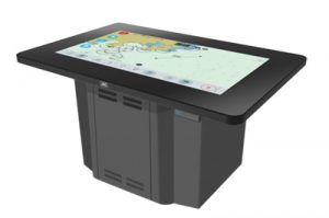
Alphatron Marine, a navigation technology provider that’s a subsidiary of Japan Radio Company (JRC), has introduced the Navigation Electric Conning Station Table (NeCST), a complementary tool for its ECDIS (Electronic Chart Display and Information System). The NeCST grants captains the ability to share information with ships and land and add handwritten notes to charts displayed on the ECDIS.
The ECDIS has been required on international voyages by passenger vessels over 500 gross tonnage and cargo vessels over 3,000 GT since 2018. Many captains on these voyages are still used to working on paper charts, however, and want to be able to add notes by hand.
“A lot of captains like to write notes on the paper charts,” Ramon Rodriguez, a strategic account manager at Alphatron, explained. “We give them the ability to do this on a tablet. It lets them add things like no-go zones, weather conditions like a typhoon or a hurricane or information about the currents.”
The NeCST is a 46-inch tablet; captains can write on the tablet with either their finger or a stylus. A note added to the tablet immediately updates onto the ECDIS. The system allows captains to share data with other captains in order to make voyages easier.
“If there’s a new captain, other ships can take photos of the port and share them with them,” Rodriguez said. “If the captain has never been to the port he can familiarize himself with the area.”
The system also can help more easily share data with the land and record fires or other hazards in the ship.
“These ships keep a lot of information in logs,” Rodriguez stated. “Now with NeCST, they can save them digitally and email them as a PDF file.”
The equipment is intended for larger container vessels, with JRC adding that the product is likely too expensive for fishing or excursion vessels. Rodriguez reported that a demo unit of the NeCST had been installed on a vessel operated by North Vancouver, BC-based marine services company Seaspan, and that they’ve had discussions with other ships to install the product onboard.
Raymarine
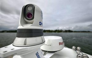
Raymarine, a global manufacturer and supplier of marine electronics, has released a new series of cameras that provide boaters with a safer navigational experience.
The new cameras apply enhanced stabilization technology to high-performance visible, thermal, or multispectral imaging, to deliver stable vision in high-stakes environments.
These Teledyne FLIR cameras can help first responders, commercial mariners, and serious boaters achieve a new level of awareness on the water.
The M300 Series — including the M300C, M364C, and M364C LR — features thermal technology that can make nighttime navigation safer and less stressful. The camera creates visuals using heat rather than visual light, giving captains the power to see clearly in total darkness, glaring light and light fog. FLIR thermal reveals subtle temperature differences in a visual that is easy to understand without additional training. FLIR cameras are used by thousands of military, first responder and commercial professionals every day for navigation, collision avoidance, threat detection and search-and-rescue missions.
In addition to the thermal camera technology, the M364C and M364C LR cameras feature FLIR’s patented Color Thermal Vision, which can help mariners capture important color information from other vessels or navigation aids at night. The technology blends thermal and high-definition visible color video for enhanced identification of buoys, vessels and other targets at night.
Active gyro-stabilization on the M300 Series compensates against rough water to keep camera visuals stable. The camera features an integrated Attitude Heading Reference Sensor (AHRS) and two-axis mechanical stabilization system, which Raymarine reports virtually eliminates the effects of pitch, heave and yaw. This feature, along with electronic stabilization further minimizes image instability from engine rumble and boat vibration.
Combining M300 Series cameras with Raymarine ClearCruise Augmented Reality enhancements makes navigation safer by overlaying Automatic Indication Systems targets, chart objects and waypoints on top of real-time video from any M300 camera, according to the company, which also has said that the series of cameras offers superior long-range imaging and positive target identification using a high-definition visible camera with 30X optical zoom.
Raymarine also has introduced its next generation of chart system, consisting of charts that are customizable and outfitted with color-shaded depth contours and data-rich points of interest.
The coverage area includes coastlines of the contiguous U.S., Alaska, Hawaii, thousands of inland freshwater bodies of water, and the Bahamas. Also included: the Great Lakes and related waterways, British Columbia, the St. Lawrence River, the coastlines of Newfoundland, Nova Scotia, Prince Edward Island and New Brunswick.
The company says its charts are compatible with Raymarine Axiom touchscreen multifunction displays, as well as Axiom+, Axiom Pro, Axiom XL and Raymarine Element.
Advanced Navigation
Advanced Navigation, an Australia-based manufacturer of inertial navigation systems, recently launched its new fiberoptic gyroscope (FOG) inertial navigation systems, the Boreas D90, which is its first fully digital FOG (Fiber Optic Gyroscope).
“DFOG represents a step change for fiberoptic gyroscopes,” Advanced Navigation CEO Xavier Orr explained. “With Boreas’ ultra-high accuracy and strategic-grade performance combined with the reduction of size, weight, power and cost by 40%, we will be able to enable new industries and applications that were never possible before.”
The Boreas D90 delivers a strategic-grade bias stability of 0.001 degrees per hour, which allows the Boreas D90 to achieve ultra-high roll/pitch accuracy of 0.005 degrees and heading accuracy of 0.006 degrees. Boreas D90 allows for full GPS independence with dead reckoning accuracy of 0.01 percent distance travelled with an odometer.
It also features ultra-fast gyrocompassing, taking only two minutes to acquire heading in stationary environments or on the move, Advanced Navigation reports. The gyrocompassing allows the system to determine a highly accurate heading of 0.01 degrees secant latitude without any reliance on magnetic heading or GPS. Boreas D90 contains Advanced Navigation’s sensor fusion algorithm, which was designed for control applications with a high level of health monitoring and instability prevention to ensure stable and reliable data.
The Boreas D90 high accuracy orientation and navigation capabilities can be used in many different capacities — not only for marine travel, but also for surveying, subsea, aerospace, robotics and space. It is the first product to be released based on Advanced Navigation’s patent pending DFOG technology — the culmination of 25 years of development.
The first generation of FOG made available in 1976 used analog signals and analog signal processing. The second generation, which uses a hybrid of analogue and digital signaling, was developed in 1994 and is still used.
The third generation of FOG sets itself apart by being completely digital, providing higher performance and reliability, while enabling a 40% reduction in size, weight, power and cost.
To achieve this, three different technologies have been developed:
First, DFOG uses a specially developed digital modulation technique passing spread spectrum signals through the coil. The new digital modulation technique introduced in DFOG technology allows in-run variable errors in the coil to be measured and removed from the measurements. This makes DFOG significantly more stable and reliable than traditional FOGs, according to Advanced Navigation, while allowing a smaller FOG with less coil length to achieve the accuracy of one with a longer coil.
Second, Advanced Navigation has introduced an optical chip that integrates five sensitive components into a single chip and removes all the fiber splices. This, the company reports, reduces the size and weight, while significantly improving its reliability and performance.
The DFOG technology was developed in partnership with Professor Arnan Mitchell, the Director of the Integrated Photonics and Applications Centre at The Royal Melbourne Institute of Technology.
Mitchell’s work on shrinking components of a fiber optic gyroscope onto a single chip proved to be one of the key components of DFOG’s technology. This innovation is what allows DFOG to have a significantly lower SWaP-C than other similar FOGs, all the while delivering higher accuracy and reliability.
“By printing optical components onto a tiny chip, we are creating more compact and reliable fiber optic gyroscopes,” Mitchell explained.
Finally, the DFOG employs a specially designed closed-loop optical coil, developed to take advantage of the digital modulation techniques. The design allows for optimum sensing of in-run variable coil errors using the new digital modulation technique and provides a very high level of protection for the optical components from shock and vibration.
ABB
ABB, a multinational technology company based in Zurich, Switzerland, has taken a step toward autonomous navigation with its Ability Marine Pilot.
“The [ABB Ability Marine Pilot] product family is rooted in ABB’s strong belief in utilizing technology to enhance human capabilities and thereby optimize operations,” ABB Media Relations and Content Manager Heli Harri said. “Today, autonomous technologies have reached a stage where it is not only feasible but very helpful to apply them to ships, to assist the crew in their jobs on board, and ensure safer, more efficient and thereby more sustainable operations.”
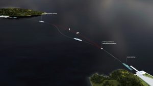
In April 2021, in partnership with Keppel Offshore and Marine, ABB carried out a remote joystick control of a tugboat in a Singapore harbor—among the first of its kind in South Asia.
The Port of Singapore, which accommodates more than 130,000 vessels annually, presented a complex challenge for autonomous vessel operation. The successful trial marked a major milestone in validating the increased safety and efficiency of tug operations utilizing digital solutions.
In the trial, a harbor tug was operated from a shore command center located at the Maritime and Port Authority of Singapore’s Maritime Innovation Lab. The tug, Keppel Smit Towage’s Maju 510, was retrofitted with the ABB Ability Marine Pilot Vision and the ABB Ability Marine Pilot Control system.
During the test, the ABB Ability Marine Pilot Vision generated a digital situational awareness, while the intelligent maneuvering and control ABB Ability Marine Pilot Control system executed the necessary intelligent maneuvering and control commands.
“We are proud to have reached another milestone representing a significant step towards autonomous shipping,” ABB Marine and Ports Division President Juha Koskela said. “The intent of this technology is to relieve the crew of tasks that can be automated, enabling them to perform at their best during critical periods and enhancing the overall safety and productivity of marine operations. This trial also confirms the possibility for application of remote and autonomous technology to other vessel types.”
Tug operations, where a tugboat maneuvers other vessels by pushing or towing them, often in crowded harbors, can be extremely demanding. Tugs often have to complete lengthy and monotonous transit legs to get to their place of operation. If the transit is instead performed autonomously under remote supervision, the onboard crew would be able to use this time to rest, according to ABB, and would theoretically be more alert when they’re needed for tug operations.
“As a tug operator, we leverage technology to improve our operations to serve our customers better. With the Maju 510 as a pilot tug, we are able to experience and provide feedback on how autonomous operations can help the tug captain and crew in simplifying their navigation to focus on crucial tasks” said Romi Kaushal, Managing Director of Keppel Smit Towage. “This has the potential to significantly enhance operational safety and efficiency.”
The autonomous technology has been developed over the course of several years.
“The ABB Ability Marine Pilot product family has evolved step by step, through extensive workshops and continuous testing together with captains and crews,” said Harri.
ABB has previously delivered technology for the groundbreaking trial of a remotely operated passenger ferry, Suomenlinna II in November 2018, proving that human oversight of vessels from any location is achievable.
Helsinki City Transport successfully completed the remote trial, which was among the world’s first for an existing passenger ferry. ABB has retrofitted Suomenlinna II with the ABB Ability Marine Pilot Control, which enabled the trial.
The ferry was wirelessly operated through a pre-selected area of Helsinki harbor from a control center in the Finnish capital.
The Singapore harbor tug project is funded by the Maritime and Port Authority of Singapore as part of the Singapore Maritime Research and Development Roadmap, which charts the nation’s key focus areas for development of the maritime industry, as well as research and technological capabilities.
The second phase of the project, scheduled for late 2021, will see the vessel perform autonomous collision avoidance tasks while under remote supervision.
With continued development of this product, it is likely to be seen on more vessels in the future.